

The fundamental steps in creating a vegetation map are the development of a standardized classification, such as the USNVC, and a key to the vegetation classes.

A predetermined set of mapping rules is necessary to create a robust and consistent vegetation map. A vegetation map is a powerful tool when it includes a suite of imbedded attributes associated with the vegetation classification.
Vegetation mapping methods vary considerably depending on needs, available resources, and the character of the vegetation.
Map products should be evaluated for quality and reliability. Accuracy should be reported and available to users.
The fundamental steps in creating a vegetation map are the development of a standardized classification, such as the USNVC, and a key to the vegetation classes.
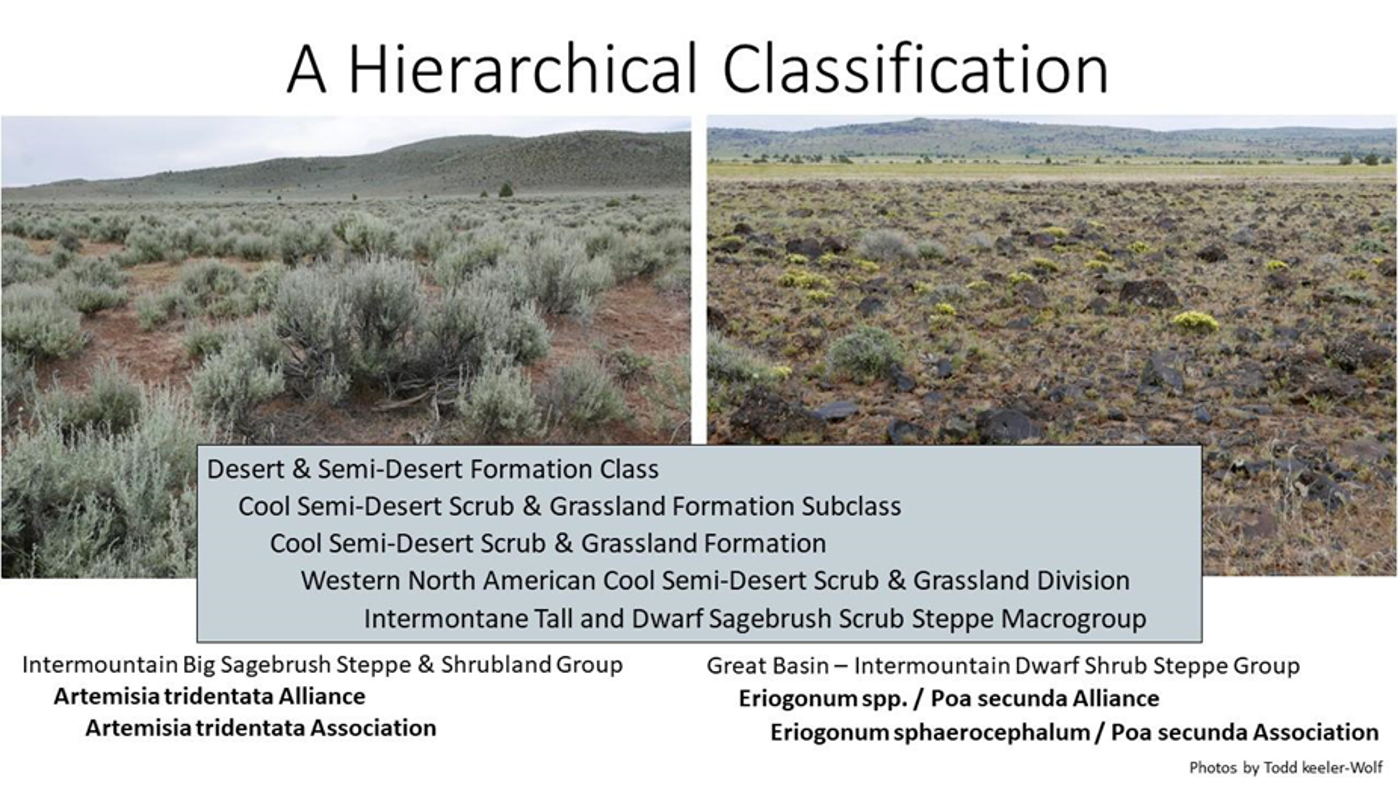
The mapping classification refers to the units being mapped. Using the United States National Vegetation Classification (USNVC) standard, a map can have a mapping classification that is at any one of eight levels of the hierarchy, from the generalized class of “Desert & Semi-Desert Formation Class” down to Macrogroup, Group, Alliance, and/or Association at the finest scales of classification, each describing an increasing level of thematic resolution, respectively.
A predetermined set of mapping rules is necessary to create a robust and consistent vegetation map. A vegetation map is a powerful tool when it includes a suite of imbedded attributes associated with the vegetation classification.
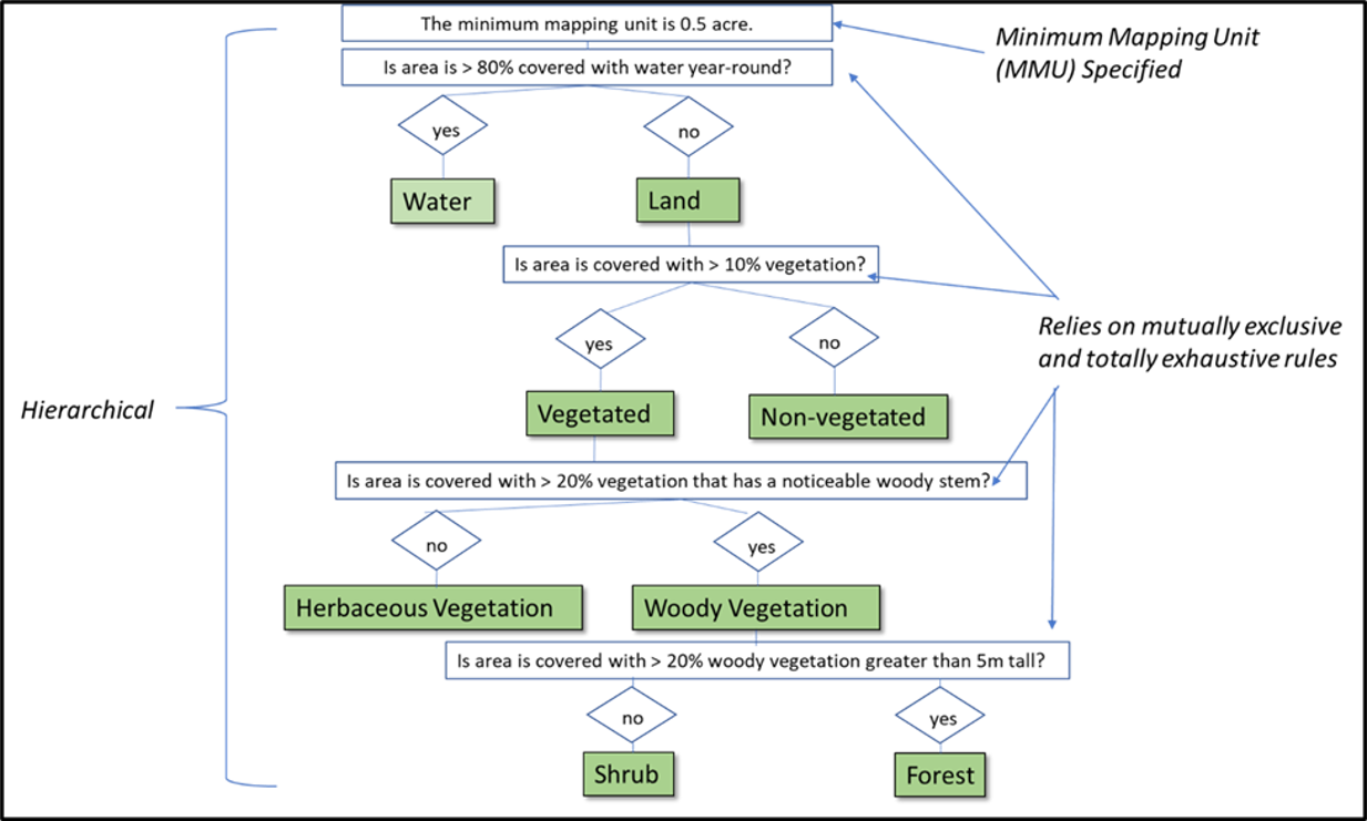
A predetermined set of mapping rules, or a mapping scheme, is necessary to create a robust and consistent vegetation map.
Vegetation mappers establish mapping rules that consistently represent a set of vegetation map units.
For a vegetation map to be robust, the rules must be constrained by a specified minimum mapping unit as well as:
- Totally exhaustive – the scheme captures all the meaningful variation found on the ground, resulting in every single area on the map falling into one of the map classes in the scheme.
- Hierarchical – Nesting of lower and higher levels in the USNVC
- Mutually exclusive – each and every object is clearly labeled by one and only one map class type.
Vegetation mapping methods vary considerably depending on needs, available resources, and the character of the vegetation.
A vegetation map describes patterns and differences in terrestrial ecosystems across the landscape. A vegetation map legend can include:
- thematic differences in floristic composition
- horizontal and vertical structure of the diagnostic plant species
- human or natural disturbance categorical information
Map attributes provide the ability to encompass multiple independent layers, making vegetation map powerful tools for land use planning and management.
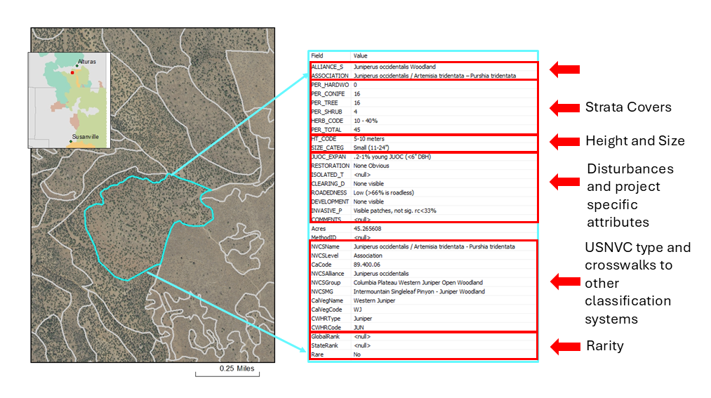
An example of the map attributes (map legend) included in a polygon of Western Juniper (Juniperus occidentalis) in a fine-scale vegetation map from Modoc County, California.
Map products should be evaluated for quality and reliability. Accuracy should be reported and available to users.
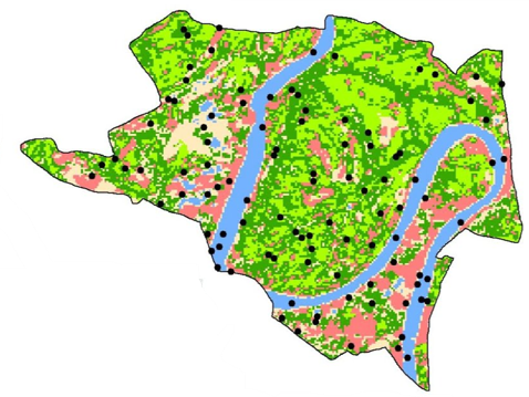
A land cover accuracy assessment evaluates a land cover map by comparing its classifications to ground truth data using a confusion matrix to calculate metrics like overall accuracy (OA), user’s accuracy (UA), producer’s accuracy (PA), and the Kappa coefficient. This process is crucial for understanding a map’s reliability, identifying specific areas of error, and improving its overall scientific and practical value.
Process of a Land Cover Accuracy Assessment:
1. Create Sample Points: Select a representative sample of locations within the mapped area to be assessed.
2. Obtain Ground Truth: For each sample point, determine the actual land cover type on the ground. This “ground truth” can be derived from various sources, such as high-resolution imagery (e.g., from Google Earth Pro), field surveys, or existing reference datasets.
3. Compare Map to Ground Truth: Compare the land cover class assigned by the map at each sample point with the corresponding ground truth data.
4. Construct a Confusion Matrix: A confusion matrix is a table that summarizes the comparison results, showing how many samples were correctly or incorrectly classified for each land cover class.
Accuracy Assessment
Esri. (n.d.). Accuracy Assessment—ArcGIS Pro. Retrieved September 9, 2025, from https://pro.arcgis.com/en/pro-app/latest/help/analysis/image-analyst/accuracy-assessment.htm
Photo credits: Don Faber-Langendoen, Todd Keeler-Wolf